
Space matters: setting parking requirements with data
Parking takes up a lot of space in cities, on the street and inside buildings. Yet many cities still ask developers for the same number of parking spaces everywhere, whether a building is next to a tram stop or far from one. FLEKS uses data to set parking zones that match how people actually live.

1. Space is the cities’ nightmare
The more people move to the city, the scarcer space becomes, and different needs end up fighting over it. Who should get our scarce space: housing? Public transport and streets? Parks? Or parking…
Space efficiency is an opportunity to improve what the city offers, and everyone can benefit from it. For the city, it means being able to provide more services in the same limited space. For residents, it means more space for other uses like greenery instead of a garage. And for housing construction, it means lower costs.
2. How can cities improve space efficiency?
Space efficiency is a general city strategy. Munich, for example, has made it part of its Mobility Strategy 2035. Until now, the different uses of a street, such as driving, parking, walking, cycling and trees, were often planned one by one. The sub-strategy on managing public (street) space, adopted in 2025, looks at the street as one shared space and decides together how much of it each use gets. It argues that more of this space should go to walking, cycling and public transport, and space efficiency is one of the main reasons it gives.
Mobility is, in the end, just a way to get from one place to another, yet the space we allocate to movement takes up a large share of the city. In Berlin, roads, paths, squares and rails cover about 15% of the city’s area, and around a quarter in central districts like Mitte and Friedrichshain-Kreuzberg. We use streets to move, but they stay there even when no one is using them. The same goes for our parking spaces at home while we are at work.
So how can cities use this space better? Two common strategies:
- Shifting the mode share. Mode share is how trips in a city are split between car, public transport, bike and walking. Cities try to move more of those trips away from the car, because it is a space-inefficient mode of transport. As the picture below shows, moving 72 people by car takes far more space than moving them by bus or by bike. And this space is needed not only on the street but also for parking.
- Managing parking. Instead of building more parking, cities make better use of what exists: spaces shared between different users at different times, or parking sized to the actual demand.
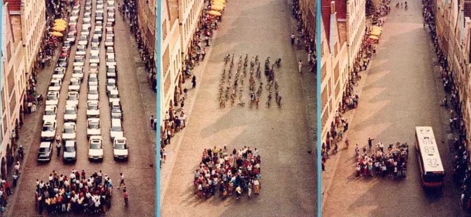
The space needed to move 72 people by car, bus and bike. Photo: Press Office, City of Münster
We often think of the city’s role only in public space, but regulations also shape how efficiently private space is used. Many German cities have a parking regulation system that requires housing developers to build parking. The goal is to keep residents from relying heavily on public parking or parking along the street, which can cause other problems.
Why set a minimum? Because many developers in big cities would rather not build garages or underground parking. They are expensive: in urban areas, a single underground parking space can cost between €50,000 and €100,000. This raises construction costs and, in the end, the rent for residents. So cities have to find a balance. If developers build too many spaces, residents pay for parking that nobody uses. If they build none at all, cars end up parked on the street, in public space. Instead of one rule for every building, more and more German cities now set the requirement according to where and what is being built.
3. How cities are changing their parking requirements
With recent changes to parking requirements in Germany, many cities have moved from a one-size-fits-all concept (like one parking space per apartment) to a more flexible system that better reflects citizens’ needs. In German cities, the common adjustment factors are:
- Dwelling size
- Social housing
- Location, often by splitting the city into zones
- Additional mobility measures, for example providing shared bikes, which can reduce the need for a car
In the following table we compared 12 German cities: the year their parking requirements were adopted, the base number per dwelling, and the factors they use to adjust it.
| City | Year | Parking requirement (per dwelling) | Dwelling size | Social housing | Location | Mobility measures |
|---|---|---|---|---|---|---|
| Bremen | 2022 | 0.8 | ✕ | ✕ | ✕ | ✕ |
| Freiburg | 2016 | 1 | ✕ | ✕ | ✕ | |
| Düsseldorf | 2019 | 1 | ✕ | ✕ | ✕ | |
| Aachen | 2025 | 0.8 | ✕ | ✕ | ✕ | ✕ |
| Bonn | 2025 | 0.8 | ✕ | ✕ | ✕ | ✕ |
| Leipzig | 2019 | 0.7 | ✕ | ✕ | ✕ | |
| Potsdam | 2021 | 0.5 | ✕ | ✕ | ||
| Dresden | 2018 | 1 | ✕ | ✕ | ✕ | |
| Frankfurt am Main | 2022 | 1.1 per 100 m² | ✕ | ✕ | ✕ | |
| Stuttgart | 2023 | 1 | ✕ | ✕ | ||
| München | 2016 | 1 | ✕ | ✕ | ✕ | |
| Ulm | 2020 | 0.8 | ✕ | ✕ | ✕ |
Even though we benchmarked German cities, other countries such as France and Austria apply similar regulations.
4. Which numbers to choose and how to define the zones?
We can clearly see trends in how cities choose the factors and parameters that shape residential parking requirements. These trends reflect some of the components that influence the demand and need for parking spaces. However, how each city sets its base parking requirement, and how much it varies per parameter, is not always transparent. It is often unclear whether the values come from expert experience, political choices, or an analytical method.
At Plan4Better, we suggest starting with the data. We look at how many cars residents own today, and at what surrounds them: public transport, shops and services, density. Together, these show how the place people live in shapes how many parking spaces they need. From there, the city can be divided into parking requirement zones based on evidence rather than habit. The method builds on an approach that TU Hamburg developed using data from Hamburg and Osnabrück. We adapted it in a project with the City of Munich to define the city’s parking zones for residential areas. We call this method FLEKS, short for Flexibilisierung Kommunaler Stellplatzsatzungen (making municipal parking regulations more flexible).
5. How does FLEKS work?
FLEKS works in two steps. First, it learns from today. The city is divided into small squares, for example the 100 × 100 m census grid. For each square, we know how many cars people own and what is around them: how good public transport is, how far the nearest shops are, how dense the area is, and some social characteristics. Comparing all these squares shows how much each of these things pushes car ownership up or down.
Then, it uses what it learned. For any place, FLEKS combines these effects into one estimate: how much car parking per dwelling the people living there would need. This also works for places that don’t exist yet, like a new housing development, or for a scenario like a new tram line. At this fine scale, it is “just” a very detailed car ownership model.
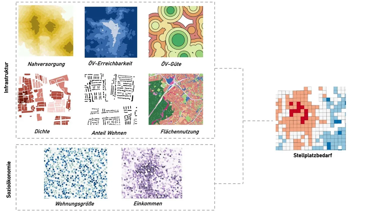
The layers that can feed the model of parking demand per dwelling: public transport, shops and services nearby, density and social characteristics.
But a resolution this fine is not practical for planning and political decisions. The parking requirement zones defined by the city need to be more aggregated, while keeping as much of the detail as possible. That is why FLEKS is not only a car ownership model: it turns the model into a planning tool. From the model results, we build zones that group areas with similar parking demand, and then clean them up so the zones stay coherent and easy to apply in practice. On top of each zone’s minimum parking requirement, FLEKS gives real estate developers a tool to adjust it further for their own project, based on its mix of dwelling sizes and types. It also allows for additional reductions when the project provides mobility services such as car sharing.
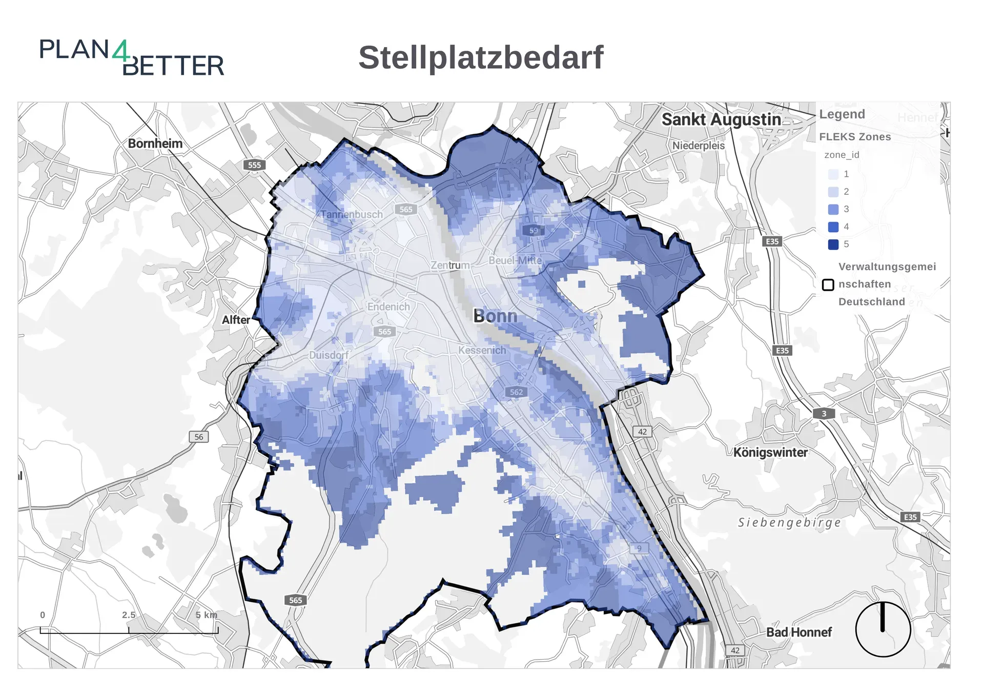
FLEKS applied in Bonn: the resulting parking requirement zones.
6. What can a city do with FLEKS?
FLEKS started as a way to set parking requirements for housing. But once it is calibrated for a city, it can answer more questions than that.
- Set parking zones for the whole city. FLEKS is calibrated on local car ownership data. It then gives zones with a minimum parking requirement based on how people actually live, instead of one number for everyone.
- Adjust the requirement for one project. Developers start from their zone’s minimum and adjust it for their mix of dwelling sizes and types. They get further reductions when they offer mobility services such as car sharing.
- Test scenarios before deciding. Change the infrastructure in an area, for example a better ÖV-Güteklasse after a new tram line, and see how parking demand changes there.
- Update the zones when the city changes. New transit lines and new shops change what people need, so the zones can be recalculated with the new situation.
- Go beyond residential parking. FLEKS can be applied to other types of developments.
All of these start from the same idea: begin with the data, not with a number chosen out of habit.
References
- Landeshauptstadt München, Mobilitätsreferat (2025). Mobilitätsstrategie 2035, Teilstrategie: Management des öffentlichen (Straßen-)Raums. Sitzungsvorlage Nr. 20-26 / V 11904. risi.muenchen.de
- Stiftung Lebendige Stadt / TU Hamburg, Institut für Verkehrsplanung und Logistik (2021). Pkw-Besitz im Wohnungsbau: Eine Handreichung zur Ermittlung flexibler Stellplatzschlüssel. lebendige-stadt.de
- TU Hamburg, Institut für Verkehrsplanung und Logistik. Stellplatzschlüssel und Mobilitätskonzepte im Wohnungsbau (research project page). tuhh.de
- Amt für Statistik Berlin-Brandenburg (2023). Pressemitteilung Nr. 194: Flächenerhebung zum 31.12.2022. statistik-berlin-brandenburg.de
Frequently asked questions
What is FLEKS?
FLEKS, short for Flexibilisierung Kommunaler Stellplatzsatzungen, is a method developed by Plan4Better to define residential parking requirement zones from data. It models car ownership per dwelling at a fine scale. It then groups areas with similar parking demand into zones that a city can use in its parking regulations.
How do German cities set parking requirements for new housing?
Many German cities require housing developers to build a minimum number of parking spaces. More and more cities are moving away from one fixed ratio, such as one space per apartment. Instead, they vary the requirement by dwelling size, social housing, location zone and additional mobility measures.
Why base parking requirements on data?
Car ownership today, combined with what surrounds each home, shows how many cars people really need in a given place. This gives the city an evidence-based starting point. In many cities it is unclear whether current parking requirements come from expert experience, political choices or an analytical method.
What data does FLEKS need?
FLEKS works with the fine-scale data a city already has, for example the 100 x 100 m census grid. It uses indicators such as public transport quality, density, shops and services nearby and social characteristics. These are calibrated against existing car ownership data.
Can developers reduce the parking requirement for their project?
Yes. On top of each zone's minimum, FLEKS gives developers a tool to adjust the requirement based on the project's mix of dwelling sizes and types. It also allows further reductions when the project provides mobility services such as car sharing.
Where has FLEKS been used?
FLEKS builds on an approach that TU Hamburg developed using data from Hamburg and Osnabrück. Plan4Better adapted it in a project with the City of Munich to define the city's parking zones for residential areas.
Can FLEKS be used in other cities?
Yes. FLEKS can be calibrated for another city using that city's own data. It can also run scenarios for specific projects or areas, and it can be adapted for use cases beyond residential parking.